发布时间:2025年9月24日 16:37
类别:
Page Views: 9 views
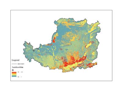
The dataset primarily records land use data on the Loess Plateau, covering the time period from 1987 to 1990. The data format is raster data. It was collected and compiled by the Institute of Geographic Sciences and Natural Resources Research, Chinese Academy of Sciences. This dataset can be utilized for scientific research, teaching, and government decision-making.
title
黄土高原土地利用遥感数据集(1987-1990)
anytext
dddd_loess_500M_grid_landuse(1987-1990)_b黄土高原数据。数据量: 107.3 MB。
abstract
数据集主要记录黄土高原土地利用数据,时间范围为自1987-1990年。数据格式是栅格数据。数据由中国科学院地理科学与然资源研究所收集及整理,可用于科研、教学和政府决策。
operation
通过校正、剪切和指数计算,得到黄土高原地区资源环境遥感数据。数据处理软件包括ArcGIS和EnVI。首先,对获取的遥感数据进行校正和处理。然后,利用ArcGIS进行指标计算和分类。最后,将上述结果添加到栅格化的资源环境数据中
organization
中国科学院地理与资源环境研究所,地址:北京市朝阳区大屯路甲11号
topicategory
地理科学,环境科学,区域可持续发展,地球科学
distancevalue
该数据集的覆盖地区为黄土高原