发布时间:2025年9月24日 16:37
类别:
Page Views: 9 views
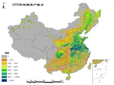
The China Farmland Production Potential Dataset is developed based on data including China's cultivated land distribution, soil properties, and digital elevation model (DEM), utilizing the Global Agro-Ecological Zones (GAEZ) model. It integrates multiple factors such as light, temperature, water, CO₂ concentration, pests and diseases, agro-climatic constraints, soil conditions, and topography to estimate the production potential of China's cultivated land.
This dataset serves to investigate the impacts of cultivated land and climate change on food production potential, reveal spatial patterns and regional differentiation rules of how China's climate and cultivated land changes have affected food productivity over the past two decades, clarify the differential impacts of these two factors on food production potential, and provide decision-making references for land resource development, cultivated land protection, and ensuring national food security under global change scenarios.